DigitalGlobe-Imagery – Flickr

Earthquake and Tsunami near Sendai, Japan on March 11, 2011

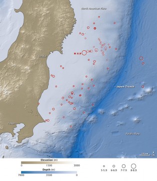
On March 11, 2011, at 2:46 p.m. local time (05:46 Universal Time, or UTC), a magnitude 8.9 earthquake struck off the east coast of Japan, at 38.3 degrees North latitude and 142.4 degrees East longitude. The epicenter was 130 kilometers (80 miles) east of Sendai, and 373 kilometers (231 miles) northeast of Tokyo. If the initial measurements are confirmed, it will be the world's fifth largest earthquake since 1900. This map shows the location of the March 11 earthquake, as well as the foreshocks (dotted lines) and aftershocks (solid lines). The size of each circle represents the magnitude of the associated quake or shock. The map also includes land elevation data from NASA's Shuttle Radar Topography Mission and ocean bathymetry data from the British Oceanographic Data Center.
Bild: Twitter

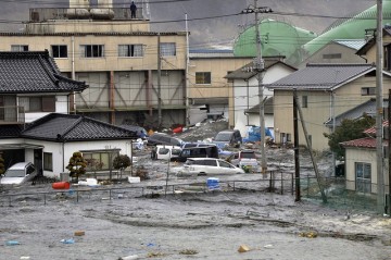
A tsunami, tidal wave smashes vehicles and houses at Kesennuma city in Miyagi prefecture

A tsunami, tidal wave smashes vehicles and houses at Kesennuma city in Miyagi prefecture, northern Japan on March 11, 2011. A massive 8.9-magnitude earthquake shook Japan, unleashing a powerful tsunami that sent ships crashing into the shore and carried cars through the streets of coastal towns. AFP PHOTO / YOMIURI SHIMBUN (JAPAN OUT, RESTRICTED TO EDITORIAL USE) (Photo credit should read STR/AFP/Getty Images)

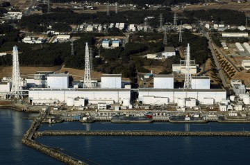
The quake-damaged Fukushima nuclear power plant in the Japanese town of Futaba

An aerial view shows the quake-damaged Fukushima nuclear power plant in the Japanese town of Futaba, Fukushima prefecture on March 12, 2011. Japan scrambled to prevent nuclear accidents at two atomic plants where reactor cooling systems failed after a massive earthquake, as it evacuated tens of thousands of residents. Tokyo Electric Power, which runs the plants, said it had released some radioactive vapour into the atmosphere at one plant to relieve building reactor pressure, but said the move posed no health risks. AFP PHOTO / JIJI PRESS (Photo credit should read STR/AFP/Getty Images)

Beacon Radio – Flickr

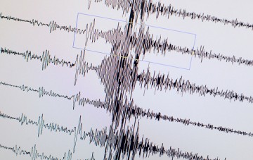
Japan Earthquake

A monitor displays the seismological chart of the earthquake which hit Japan on March 11, 2011 at the Geozentrum geological science center in Hanover, central Germany. At least 40 people were killed and 39 missing in the massive 8.9-magnitude earthquake that hit Japan, unleashing huge tsunamis along its Pacific coast, police said. AFP PHOTO PETER STEFFEN GERMANY OUT (Photo credit should read PETER STEFFEN/AFP/Getty Images)

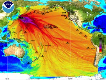
maximum computed tsunami amplitude

SEATTLE, WA - MARCH 11: In this handout image provided by the National Oceanic and Atmospheric Administration (NOAA), model amplitudes calculated with the MOST forecast model are seen March 11, 2011. Filled colors show maximum computed tsunami amplitude in cm during 24 hours of wave propagation. Black contours show computed tsunami arrival time. A magnitude 8.9 strong earthquake hit the northeast coast of Japan causing Tsunami alerts throughout countries bordering the Pacific Ocean. (Photo by NOAA Center for Tsunami Research via Getty Images)

DLR Portal – TerraSAR-X-Bild des Monats: Erdkrustenbewegungen in Haiti beim Erdbeben vom 12. Januar 2010