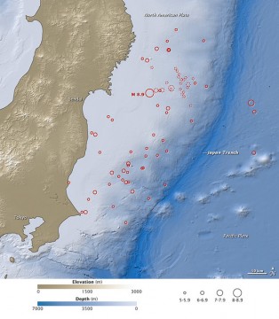
Earthquake and Tsunami near Sendai, Japan on March 11, 2011

On March 11, 2011, at 2:46 p.m. local time (05:46 Universal Time, or UTC), a magnitude 8.9 earthquake struck off the east coast of Japan, at 38.3 degrees North latitude and 142.4 degrees East longitude. The epicenter was 130 kilometers (80 miles) east of Sendai, and 373 kilometers (231 miles) northeast of Tokyo. If the initial measurements are confirmed, it will be the world's fifth largest earthquake since 1900.
This map shows the location of the March 11 earthquake, as well as the foreshocks (dotted lines) and aftershocks (solid lines). The size of each circle represents the magnitude of the associated quake or shock. The map also includes land elevation data from NASA's Shuttle Radar Topography Mission and ocean bathymetry data from the British Oceanographic Data Center.
Bild: Twitter
