Looking Inside Hurricane Rina

After a two-week period without any named storms, the 2011 Atlantic hurricane season revived in late October with the arrival of Hurricane Rina. The storm, which began as a tropical depression on October 23 in the western Caribbean, is adding misery and destruction to a region that has been battered by heavy rain and flooding events. The Tropical Rainfall Measuring Mission (TRMM) collected these images of Rina at 8:06 Universal Time (3:06 am Central Daylight Time) on October 26, 2011, while located about 200 miles (330 kilometers) east of Belize. The top image shows a nadir, or straight down, view of rain intensities within Rina. Rain rates in the center of the field of view (or swath) are measured by the TRMM Precipitation Radar (PR). Those in the outer edges of the swath come from the TRMM Microwave Imager (TMI). Rain rates are overlaid on visible and infrared data from the TRMM Visible Infrared Scanner.

Tropical Cyclone Jasmine

By February 8, 2012, Tropical Cyclone Jasmine had traveled eastward past the island of New Caledonia. The Moderate Resolution Imaging Spectroradiometer (MODIS) on NASA’s Terra satellite captured this natural-color image at 9:45 a.m. local time on February 9, 2012. That day, the U.S. Navy’s Joint Typhoon Warning Center (JTWC) reported that Jasmine had maximum sustained winds of 105 knots (195 kilometers per hour) and gusts up to 130 knots (240 kilometers per hour). Located roughly 510 kilometers (275 nautical miles) east-southeast of Noumea, New Caledonia, the storm was expected to continue moving in an eastward direction and to weaken. NASA image courtesy Jeff Schmaltz, LANCE/EOSDIS MODIS Rapid Response Team at NASA GSFC. Caption by Michon Scott.

EUMETSAT IPPS animation –

EUMETSAT IPPS animation –

EUMETSAT – Image Gallery – Topical Images

On Saturday 1 October 2011, a large area of high pressure sat over parts of Europe bringing cloud-free, very hot weather conditions, an unusual occurrence at this time of the year. Some parts of Europe experienced record-breaking temperatures.

Chernobyl Nuclear Power Plant – April 1997

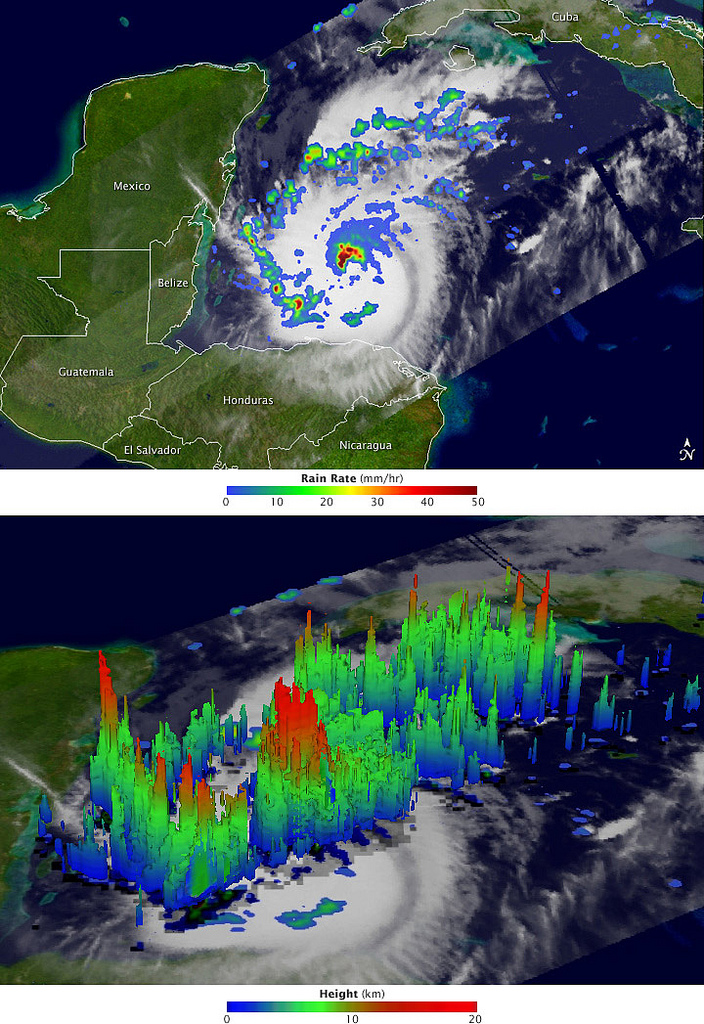
Image acquired April 27, 1997 To view the high res file go to: earthobservatory.nasa.gov/IOTD/view.php?id=4429 On April 26, 1986, the world’s worst nuclear power accident occurred at the Chernobyl Nuclear Power Plant near the Ukrainian-Belarus border. Toxic radionuclides like Cs137 and Sr90 contaminated an area of 155,000 square kilometers in what is today Belarus, Ukraine and Russia. Hundreds of thousands of people were killed, sickened from radiation-induced illnesses, or resettled to uncontaminated land. Today, the immediate area remains off limits to humans. The plant was permanently closed in 2000. The surrounding agricultural land has been abandoned, and the two nearby towns (Pripyat to the north and Chernobyl to the south) where plant workers lived are largely ghost towns. Instead of people, abundant wildlife—packs of wolves, deer, and birds—roam and live near Chernobyl. 
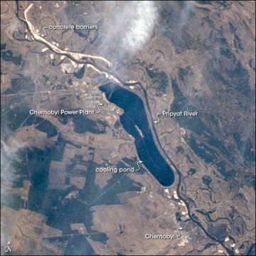
This image, taken from the Russian Mir spacecraft, shows Chernobyl and the surrounding countryside. The power plant is situated on the northwest end of a cooling pond on the Pripyat River, which flows into the Dnepr River just 80 miles north of Kiev. The main features visible in the image are the massive concrete dams and levees that were constructed to contain elements of the power plant and prevent contaminated runoff from entering the local streams. The cooling water canals leading to the pond, and the levees in the middle of the pond that channeled the water circulation can also be seen. The darker green regions are forests and the light green areas are cleared land used for agriculture. Image NM23-745-116 was taken April 27, 1997, from the Russian Mir Space Station with a Hasselblad medium format camera equipped with a 250-mm lens and is provided by the Earth Observations Laboratory, Johnson Space Center. The NASA-Mir program was the first phase of the International Space Station Program, which now supports the Earth Observations Laboratory. The program trains astronauts to take pictures of Earth that are of value to scientists and the public, and to make those images freely available on the Internet. Additional images taken by astronauts and cosmonauts can be viewed at the NASA/JSC Gateway to Astronaut Photography of Earth. Instrument: Photograph Credit: NASA Earth Observatory

Gaddafi Compound, Tripoli, Libya

Gaddafi Compound, Tripoli, Libya-August 23, 2011: This is a satellite image of the Gaddafi compound in Tripoli, Libya imaged on August 23, 2011 at 12:01 pm local time. Bomb damage to the facility was noted in June 2011. Activity noted on this image is a set of vehicles just south of the compound in the traffic circle and cars as road blocks on the road to the northeast. (credit: DigitalGlobe) www.digitalglobe.com

Fort Calloun Nuclear Power Plant, Nebraska

Fort Calhoun Nuclear Power Plant, Nebraska-June 28, 2011: This is a satellite image showing flooding at the Forst Calhoun Nuclear Power Plant. The plant is adjacent to the Missouri River which is at near maximum levels due to a due to the Missouri River basin receiving nearly a years supply of rainfall in May. (credit:DigitalGlobe) www.digitalglobe.com

Japan’s Coastline Before and After the Tsunami

These images show the effects of the tsunami on Japan's coastline. The image on the left was taken on Sept. 5, 2010; the image on the right was taken on March 12, 2011, one day after an earthquake and resulting tsunami struck the island nation.
NASA

NASA Goddard Photo and Video – Flickr